 |
| Flowers in bloom on Nogodan Peak in Jirisan National Park |
At the end of April last year I was lucky to get some time off work and decided to take the opportunity to do a multi-day hike in one of Korea's most famous national parks, Jirisan (지리산국립공원). I was hoping to do the main trail along the ridge-line that hits most of the peaks in the park and is meant to take 2-3 days.
To get there, we caught a bus from Pohang to the city of Jinju (진주), which takes about 4 hours. We only had a half day to walk around the city after the bus journey, but I was surprised at how nice Jinju was. Compared with other cities I've visited in Korea, it felt much more quiet and relaxed, perhaps because of the big river that moves slowly through the center of the city.
 |
| River walk in Jinju |
The river has trails along either side with parks and recreational areas, and as we followed it, we found ourselves at the Jinju fortress, which had a really nice surrounding garden. There was an interesting portrait of a woman in one of the rooms, and the story about her said that she had thrown herself and a Japanese officer off of a cliff, in an act of pretty extreme patriotism.
 |
| Entrance to Jinju Fortress (Jinjuseong - 진주성) |
 |
| Pavilion |
 |
| Portrait of the patriotic lady |
 |
| Temple at Jinju Fortress |
The walk through the garden around sunset had great views of the city and the river. In the fall, Jinju hosts a lantern festival on this river that draws thousands of tourists. From the photos it looks pretty spectacular, so I'm hoping to make it one day while I'm in Korea. Click here for more info about the festival.
 |
| View of Jinju Fortress from across the river |
The next day we got a bus out of Jinju to a rural area called Gurye (구례), where we could catch one more bus out to the entrace of Jirisan National Park. There are actually several main entrances to the park, but we chose to enter from the west side by Hwaeomsa (화엄사). At this entrance there is a campground (which was closed when we were there at the end of April) and an information center. We picked up detailed maps in both English and Korean before beginning our trek.
 |
| We started at Hwaeomsa, at the far left of the map (photo credit) |
Our goal was to hike from the Hwaeomsa entrance to the park up to Nogodan mountain hut where we had a reservation to spend the night. In Jirisan, you are not allowed to camp except for in designated areas, which I have no problem with, however, along the ridge-line there are no designated campgrounds (that I could find anyway). Which means that you are essentially required to stay in the mountain huts if you want to do the multi-day hike along the ridge.
Although we had a late start thanks to all the rural bus connections, we managed to make it to Nogodan just as the sun was setting. It was a long hike straight up, and the last hour was pretty steep. Or maybe I was just out of shape. Either way, it wasn't an easy climb for me with a full bag of supplies, including a tent. But the trail was lovely, passing through forests with little creeks and best of all, we had it entirely to ourselves.
 |
| Small waterfall on the way up to Nogodan |
 |
| Taking a quick break |
 |
| That bear does not look like it plans on messing around |
The Nogodan mountain shelter was an odd and quintessentially Korean experience. The facilities were actually really nice, with a big bunk room that could sleep probably around 30 or 40 people, a kitchen and dining room in a separate building, and everything was very clean. The staff were a little grumpy at first, I don't think they were expecting to see us despite our reservation, but in the end they were pretty helpful.
 |
| I might be smiling, but I was dead from exhaustion on the inside |
 |
| Nogodan shelter |
 |
| Sunset from Nogodan shelter |
I wasn't a big fan of staying at the shelter. The dining hall and kitchen were locked at about 7:30pm, just about a half an hour after we arrived. We were shown to our bunks (simple wood platforms, you need to bring your own bedding) and then at exactly 8pm the lights were out. We had just arrived and hadn't eaten anything and had been hoping to cook a hot meal after a long day of hiking and riding buses. It was pretty disappointing to spend the rest of our evening hunched over in the dark on our bunks eating trail mix for dinner. (Also, be sure to bring earplugs if you stay in one of the huts - the snoring is unbelievable.)
If you plan to stay in a mountain shelter in the park, you will need to make an online reservation before you go. This park is extremely popular, so it will fill up quickly - be sure to book it in advance. You can make a reservation here.
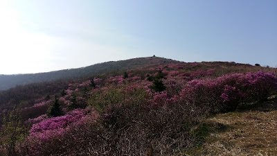
The day we climbed up to Nogodan was exactly two days before the ridge trail opened. Which meant that the next day, there were still 24 hours to go until the official opening. We were hoping that we might be able to slip by or even be let through since it was so close to the opening date; but alas, no luck. We hiked up past Nogodan in the morning to Nogodan peak, where we had a gorgeous view of the azaleas in bloom and could see the entire ridge spread out before us like an invitation. The weather was gorgeous. But unfortunately, the gate was locked and guarded and we had to turn around.
 |
| View from Nogodan in the morning |
 |
| Looking up toward Nogodan Peak |
 |
| The ridge we had planned to hike, sadly closed off to us |
It was pretty disappointing to be unable to do the entire trail. Because of our work schedules, there was absolutely no way we could have waited an extra day to start the hike. But we had to respect the rules of the park, so we came up with a different plan.
We hiked off of Nogodan to a big parking lot that drops off the day hikers by the bus-load, and then followed the road down into the valley. While this wasn't as exciting as the hike through the park would've been, it was still pretty nice. We had great weather, and the road had some good views of the mountains, beautiful forests, and followed a river where we stopped to go wading and have a picnic lunch.
 |
| Looking down at the valley |
 |
| A pretty quiet road, heading into the valley |
 |
| "Beware the wild animals!" |
 |
| Lunchtime and river wading |
Eventually we found a nice campground along the river, technically still within Jirisan National Park. There were decent number of people camping there with us, but it wasn't too noisy and the price for camping was very cheap (somewhere around 2 or 3,000 KRW per tent.) The tiny town next to the campground was cute in a rustic way, with little shops and restaurants serving simple, tasty food.
 |
| River along the road headed into the valley |
 |
| A beautiful, quiet campground by the river |
 |
| Our campground was in the trees on the left |
 |
| Shops in the little town where we camped |
The next day we got a local bus to the small city of Namwon, where there was a connection to Pohang. The bus out of the valley to Namwon had some of the most spectacular scenery that I've ever seen in Korea; it wound past mountains, forests, rivers, rice paddies, flowering trees... I really cannot recommend visiting this area enough.
So, it wasn't the trip I was hoping for, but it was a little introduction to an area I will definitely return to in the future, to do the complete trail. If you're interested in doing the hike or visiting Jirisan National Park, the blog Korea in the Clouds has great info about the trails. Some of it is a little outdated (from 2007), but it's still a good guide to the trail and has some useful maps. Also, for detailed maps of the park, go to Naver, not Google Maps. This blog offers a good guide to using Naver Maps.
Also, here is a photo of the bus schedule (local buses that pass through the valley heading to Namwon). The times are when the bus stops in the town where we camped.


Comments
Post a Comment